The North American business of renewable energy provider Enel Green Power and software company Raptor Maps, have signed a memorandum of understanding to co-develop a platform for drone technology and artificial intelligence to reduce the operations and maintenance costs of solar assets.
Enel announced the partners will develop a machine learning platform for the inspection of utility-scale solar assets with Raptor Maps’ machine learning software Raptor Solar configured to meet that aim.
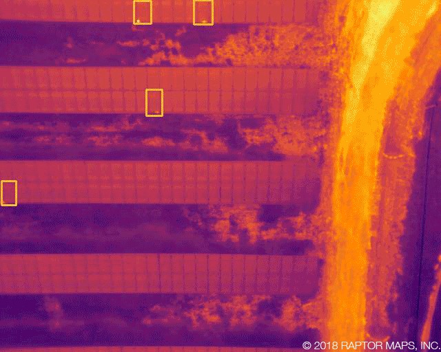
Up to now, the software has been used for post-inspection analysis and Enel seeks to embed it in its drone hardware, enabling the real-time identification and classification of solar facility faults. The companies say this process will reduce the time needed for inspection, fault detection and repair from days to hours.
“The partnership with Raptor Maps on this innovative technology goes beyond demonstrations, and implements [a] ground-breaking solution in a responsible and scalable way,” said Rafael Gonzalez, Head of Enel Green Power North America. “By combining the new software with the technologies already implemented in our plants, we have the potential to increase [the] efficiency of our inspections, yield more accurate results and work towards developing a more automated inspection process across all of our solar sites.”
Bottlenecks
The evaluation of data from drones has reportedly led to post-processing bottlenecks in the past. By enabling real-time inspection, the companies claim site technicians can be dispatched before a drone lands, removing the bottleneck.
According to the announcement, the companies want to reduce the need for transmitting large amounts of data over long distances and the project will start this month and will use all Enel's North American projects as a testing ground.
Enel expects the pilot project to be at a stage where 30 field workers can receive training in the new technology to streamline O&M processes.
Popular content
The technology will use thermal imagery and high-resolution cameras to obtain data which will be processed using AI at the source of data collection, reducing the amount of data that needs to be transferred to an evaluation center.
Other renewable applications
It will be possible, Enel says, to extend the project to other renewable energy assets at a later stage of development.
The company has already been using drones for site inspection and believes the integration of AI software will reduce OPEX even further.
Enel operates more than 4 GW of renewable energy assets in North America and has a total global capacity of around 40 GW. Such an extensive portfolio would mark a large-scale field of application for the new technology.
“Raptor Solar is revolutionizing the solar industry by enabling owners and operators to capture the most advanced PV system analytics, maximize performance, and reduce operating costs,” said Nikhil Vadhavkar, Head of Raptor Maps. “Enel is leading the industry in the scalable implementation of drones to streamline operations, maintenance and asset management. [It is] the perfect partner to push this technology to its full potential, and drive efficiency across the entire solar value chain.”
This content is protected by copyright and may not be reused. If you want to cooperate with us and would like to reuse some of our content, please contact: editors@pv-magazine.com.


By submitting this form you agree to pv magazine using your data for the purposes of publishing your comment.
Your personal data will only be disclosed or otherwise transmitted to third parties for the purposes of spam filtering or if this is necessary for technical maintenance of the website. Any other transfer to third parties will not take place unless this is justified on the basis of applicable data protection regulations or if pv magazine is legally obliged to do so.
You may revoke this consent at any time with effect for the future, in which case your personal data will be deleted immediately. Otherwise, your data will be deleted if pv magazine has processed your request or the purpose of data storage is fulfilled.
Further information on data privacy can be found in our Data Protection Policy.