Bolivian wildfires, El Niño impact South American PV irradiance

Moisture from El Niño, high pressure and the Andes all played a role in irradiance patterns across South America in November, but smoke from the wildfires in Bolivia is present clearly in the irradiance anomaly for the month, according to analysis conducted using data from the Solcast API.
Aerosols from smoke in the atmosphere absorb and scatter direct irradiance, decreasing overall irradiance and increasing the diffuse fraction of irradiance. These effects decreased irradiance over Paraguay, Northern Argentina, Southern Brazil and Uruguay, while South America’s west coast also saw lower-than-normal November irradiance, due to increased moisture from El Niño. The Andes mostly protected the rest of the continent from that moisture, and additional effects from high pressure over central Brazil meant that utility-scale solar in that region received much more irradiance than normal for this time of year.
![]()
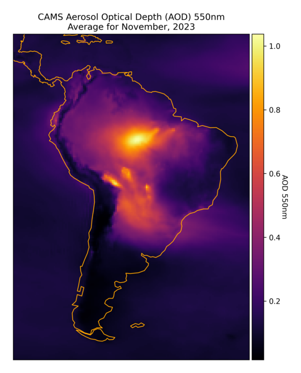
Wildfires in Bolivia generated aerosols that depressed irradiance up to 30% below long-term averages across Paraguay, Northern Argentina, Southern Brazil and Uruguay. Whilst the fires were most active through mid-November, they were concentrated enough to clearly
show in the monthly average aerosol impact (Aerosol Optical Depth), shown below.
Aerosols in the atmosphere have a significant impact on irradiance, by scattering direct irradiance high in the atmosphere. As you can see in this breakdown, aerosols had significant impacts in Sao Paolo, reducing irradiance.

Central and Eastern Brazil saw some impacts from the smoke, but not enough to prevent irradiance 20-30% over November averages. A high-pressure system in the upper atmosphere suppressed storm formation, leading to clearer skies and higher irradiance. This is a change from normal November patterns, where warm, moist air feeds showers and thunderstorms throughout Brazil. This year the many Brazillian utility-scale solar assets based in this region have benefitted from the anomalous high-pressure system, which pushed that moisture away from the area.

El Niño was fully named “El Niño de Navidad” or ‘the little boy of Christmas’, in the 1600s by fishermen who noticed warmer ocean temperatures off the coast South America in December of stormy years. Warmer Pacific waters are a key indicator of the phenomenon and bring with them increased atmospheric moisture and storms along the west coast of South America, hence the fisherman’s interest. This year these effects are already being seen, with increased cloud activity through November along the coast leading to irradiance around 10% lower than long-term averages. The Andes form a natural barrier that stops the extra moisture from pushing further east into the continent, keeping the biggest impacts of El Niño on the west coast.
Interestingly northern Chile had the highest average irradiance across the continent, but lower than normal for November. This pattern has also been present in other months, as the region from the Atacama Desert to the Altiplano Plateau is one of the most irradiated places
in the world.
The views and opinions expressed in this article are the author’s own, and do not necessarily reflect those held by pv magazine.
This content is protected by copyright and may not be reused. If you want to cooperate with us and would like to reuse some of our content, please contact: [email protected].
Please login to comment
[…] Da pv magazine Global […]
[…] Credit: Source link […]
[…] Source: PV Magazine […]