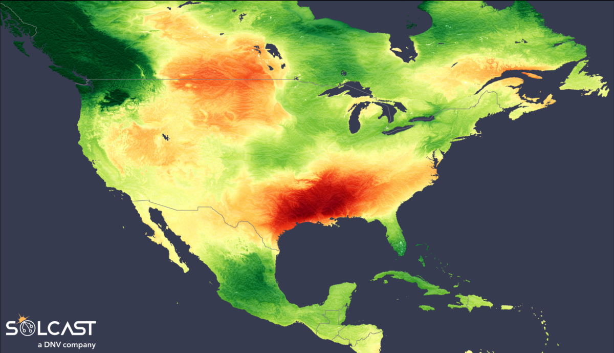
North America experienced a sharp contrast in irradiance levels, driven by a high-pressure system in the Atlantic and intense low pressure in the North Pacific. These varied patterns have impacted solar generation across the continent, in particular driving stronger than expected December irradiance in Texas, delivering a Christmas increase in generation for the large solar assets in the ERCOT region.
![]()
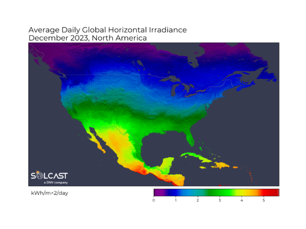
The South experienced up to 30% higher irradiance than the long-term December average, resulting from a persistent Atlantic high-pressure system driving easterly winds. which kept moisture from the Gulf of Mexico offshore. In contrast, Florida, which is more exposed to the Atlantic, faced above-average rainfall and 20% lower irradiance than long-term average. Similarly, the Northeast experienced a warm, moist south-easterly Atlantic air mass, bringing storms that left many without power and resulting in above-average rainfall and slightly below average total irradiance.
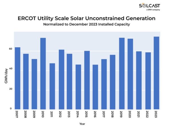
As seen in the graph above, the Solcast API simulations of the Electric Reliability Council of Texas (ERCOT) region highlight that 2023 has seen the highest hypothetical production since 2007. This analysis uses the current installed utility scale capacity, and applies previous years’ weather to model how much could have been produced with current assets. This December, Texas’ utility scale solar generation exceeded seasonal expectations, having 20% above the long-term average due to above-average irradiance. Texas is an attractive location for solar in the USA, as irradiance during the winter months is as much as 3 times higher than that seen near the northern US border. Indeed, year-on-year growth in solar in the ERCOT is currently more than 50%.
Popular content
British Columbia and Washington State faced a different scenario, experiencing 30% lower irradiance due to anomalous low pressure in the North Pacific which drove a deep, moist, and relatively warm airstream bringing heavy rainfall onshore. California saw a slightly cloudier than usual December, with total irradiance of 5-10% below long-term average. Meanwhile, the Midwest enjoyed up to 15% higher than average irradiance, as the low pressure systems in the Pacific weakened the fronts that typically move eastwards across North America in the winter. Solcast produces these figures by tracking clouds and aerosols at 1-2km resolution globally, using satellite data and proprietary AI/ML algorithms. This data is used to drive irradiance models, enabling Solcast to calculate irradiance at high resolution, with typical bias of less than 2%, and also cloud-tracking forecasts. This data is used by more than 300 companies managing over 150GW of solar assets globally.
Solcast produces these figures by tracking clouds and aerosols at 1-2km resolution globally, using satellite data and proprietary AI/ML algorithms. This data is used to drive irradiance models, enabling Solcast to calculate irradiance at high resolution, with typical bias of less than 2%, and also cloud-tracking forecasts. This information is used by more than 300 companies managing over 150 GW of solar assets throughout the world.
The views and opinions expressed in this article are the author’s own, and do not necessarily reflect those held by pv magazine.
This content is protected by copyright and may not be reused. If you want to cooperate with us and would like to reuse some of our content, please contact: editors@pv-magazine.com.

By submitting this form you agree to pv magazine using your data for the purposes of publishing your comment.
Your personal data will only be disclosed or otherwise transmitted to third parties for the purposes of spam filtering or if this is necessary for technical maintenance of the website. Any other transfer to third parties will not take place unless this is justified on the basis of applicable data protection regulations or if pv magazine is legally obliged to do so.
You may revoke this consent at any time with effect for the future, in which case your personal data will be deleted immediately. Otherwise, your data will be deleted if pv magazine has processed your request or the purpose of data storage is fulfilled.
Further information on data privacy can be found in our Data Protection Policy.