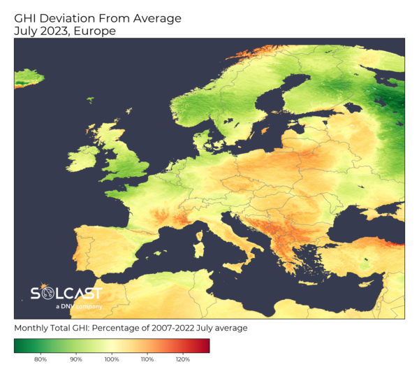
In a remarkable display of balance, July's solar irradiance averages across Europe maintained fairly typical monthly totals, despite the month being punctuated by weather extremes.
Data collected by Solcast, a DNV company, using the Solcast API, revealed a relatively normal month, with the majority of the continent seeing between 90%-110% the July average. This is despite a relatively extreme month for local weather.
While the northern regions battled storms, southern Europe was scorched by the Cerberus’ heatwave, with Spain, France, Italy, Greece and Bosnia all seeing over 40 C. Yet, despite these meteorological variances, the overall solar irradiance averages for the month remained largely normal.
The shift from the exceptionally high irradiances observed in June in the UK and France, driven by a dominant high-pressure system over the North Sea, to a more traditional summer weather pattern, was clearly discernible in NOAA data visualized below.
July was characterized by a low-pressure system extending over the UK and Scandinavia and the Azores high-pressure system exerting
influence over the southwestern region.
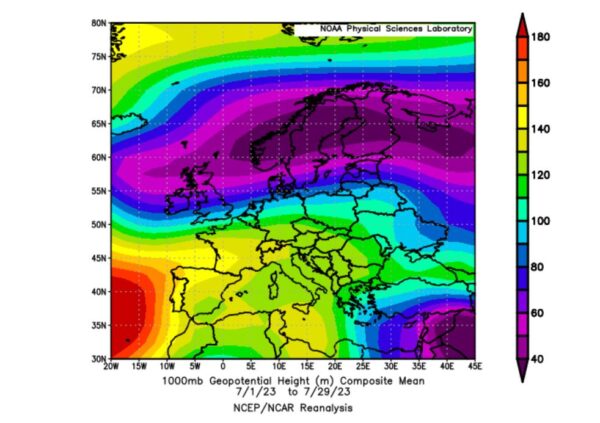
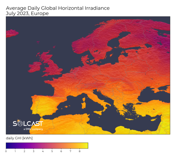
This low-pressure system, more profound than is typically observed during this period, ushered in a significant amount of moisture from the Atlantic. Consequently, this led to lower-than-average solar irradiances for regions like northern France, the UK, Benelux, and Scandinavia, as you can see in this daily irradiance map for July 27th.
![]()
Conversely, the Azores high-pressure system brought about clearer skies across southern Europe, resulting in above-average irradiances. However, these were punctuated by severe storms triggered by the collision of cold fronts with the region's heatwave-induced hot air.
Northern Italy, Switzerland, and Croatia were particularly impacted by these storms before they swept over Eastern Europe and Russia.
Hailstones as large as tennis balls caused substantial damage to photovoltaic systems near Milan, as highlighted in our article earlier this month. In Switzerland, 125 mph winds wreaked havoc.
Despite these weather extremes, the balance of solar irradiance between the stormy north and the heatwave-stricken south culminated in an overall irradiance average that remained within typical bounds for the month of July.
This reaffirms nature's remarkable equilibrium amidst a period of significant weather fluctuations.
Solcast produces these figures by tracking clouds and aerosols at 1-2km resolution globally, using satellite data and proprietary AI/ML algorithms. This data is used to drive irradiance models, enabling Solcast to calculate irradiance at high resolution, with typical bias of less than 2%, and also cloud-tracking forecasts. This data is used by more than 300 companies managing over 150GW of solar assets globally.
The views and opinions expressed in this article are the author’s own, and do not necessarily reflect those held by pv magazine.
This content is protected by copyright and may not be reused. If you want to cooperate with us and would like to reuse some of our content, please contact: editors@pv-magazine.com.

1 comment
By submitting this form you agree to pv magazine using your data for the purposes of publishing your comment.
Your personal data will only be disclosed or otherwise transmitted to third parties for the purposes of spam filtering or if this is necessary for technical maintenance of the website. Any other transfer to third parties will not take place unless this is justified on the basis of applicable data protection regulations or if pv magazine is legally obliged to do so.
You may revoke this consent at any time with effect for the future, in which case your personal data will be deleted immediately. Otherwise, your data will be deleted if pv magazine has processed your request or the purpose of data storage is fulfilled.
Further information on data privacy can be found in our Data Protection Policy.