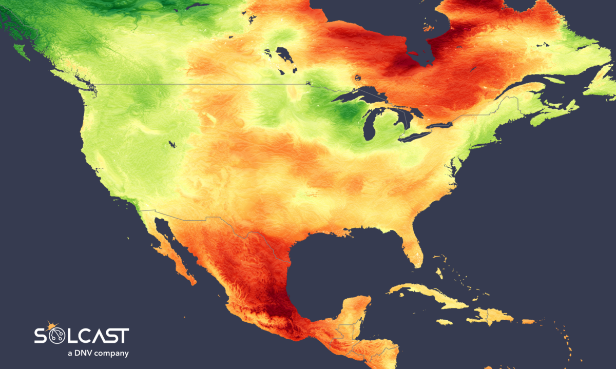
Anomalous high pressure has delivered clear skies and high irradiance across both Mexico and eastern Canada whilst cloud associated with rain and storms depressed irradiance on the west coast of the US and Canada. Areas across Mexico and southern Texas saw reduced cloud, leading to 120-130% of average September Irradiance, according to data collected by Solcast, a DNV company, via the Solcast API.
Storms and a ‘Bomb' cyclone caused by persistent low pressure over British Columbia delivered cloudier conditions, leading to irradiance as low as 70% of long term averages.
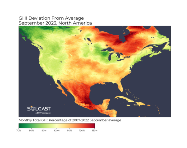
Persistent high pressure reduces large cloud formation and redirects low-pressure cloud fronts, leading to periods of clear skies. In September large high pressure systems remained for longer than normal over both eastern Canada and southwestern US and Mexico.
For solar producers, these large and persistent systems have been especially beneficial with Quebec, Ontario and southern Mexico all seeing areas with 140% of the long term September GHI average.
Months like these bode well for the future of large solar installations in the south, with ERCOT having produced 3,301 GWh of Solar in the month. Mexico is also looking to take advantage of their high solar potential, through large solar projects like the planned 1 GW Puerto Peñasco solar plant.
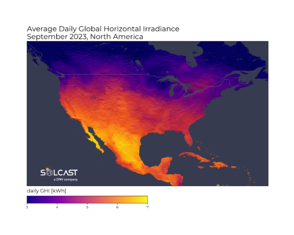
Conversely, low pressure over western Canada & Alaska pulled in cloud from the Northern Pacific, leading to a significant increase in rainfall. This plus a ‘bomb’ cyclone in late September led to reduced irradiance across all of the Pacific Coast, most noticeable in British Columbia, where some locations saw just 70% of average September Irradiance.
Rainfall across the month was 7 mm/day above the September average, and temperatures were 5 C below average. Interestingly, this pattern of high pressure keeping skies clear and creating unseasonably sunny September conditions was also seen across parts of Europe, which also saw similarly high irradiance levels.
Mexico and the southwestern US can expect these conditions to reverse through winter, as El Nino winters tend to see Mexico and the South West under-perform against non-El Nino winter averages.
Solcast produces these figures by tracking clouds and aerosols at 1-2km resolution globally, using satellite data and proprietary AI/ML algorithms. This data is used to drive irradiance models, enabling Solcast to calculate irradiance at high resolution, with typical bias of less than 2%, and also cloud-tracking forecasts. This data is used by more than 300 companies managing over 150GW of solar assets globally.
The views and opinions expressed in this article are the author’s own, and do not necessarily reflect those held by pv magazine.
This content is protected by copyright and may not be reused. If you want to cooperate with us and would like to reuse some of our content, please contact: editors@pv-magazine.com.

Good news for Mexican solar developers. Now Amlo needs to break the CFE/Pemex stranglehold and remove the 500 kW interconnect cap. Utility and commodity nationalization has its pluses, but centralized decision making is not one of them.