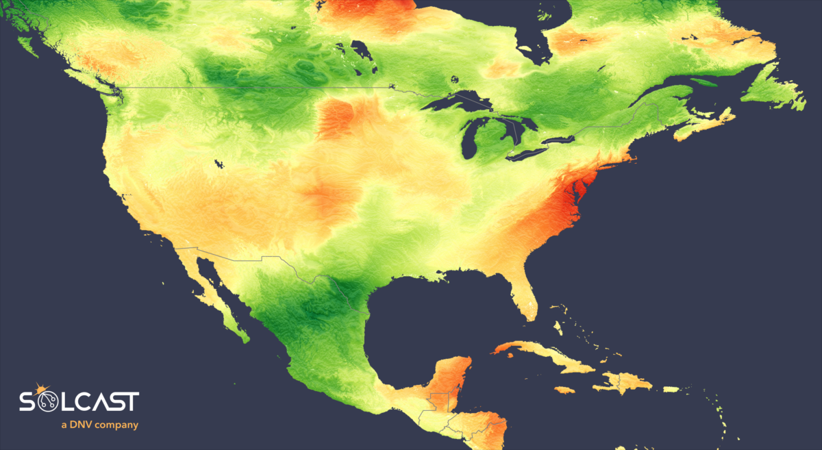
Solar asset operators across North America experienced a shift in October's solar performance, as regions that experienced higher than normal irradiance in September saw a reversal in trends, according to data collected by Solcast, a DNV company, via the Solcast API.
The East and West Coasts enjoyed particularly sunny conditions, setting records in some areas. Notably, Washington recorded the highest
October average irradiance in years, matching levels not seen since 2008. In contrast, Mexico, Texas, and central and eastern Canada were shrouded more frequently by clouds, a situation that was further intensified in Mexico by Hurricane Otis towards the end of the month.
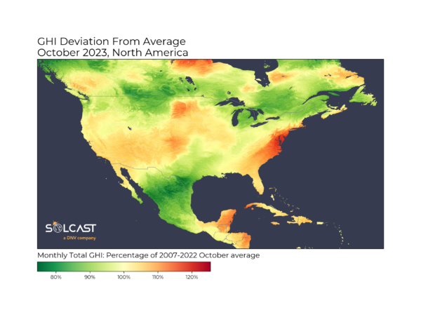
A weakened jet stream over North America caused Fall storm activity to focus offshore over the Pacific and Atlantic oceans, leading to clearer skies over the East and West Coasts. For the East Coast, this effect was particularly strong, as the Atlantic storms drew persistent offshore winds, bringing drier continental air to coastal regions.
Irradiance was above average from Cuba to New York, and Washington, Delaware and New Jersey saw up to 130% of the climatological average.
For the West Coast, the decrease in Jet Stream effects led to less moisture from California as far inland as New Mexico and the Mid West, with irradiance up more than 10% over the climatology for October. This will have benefitted the higher solar capacities in California, Nevada and Arizona, which all saw 105-110% of normal October irradiance.
Popular content
The effects of the weakened jet stream weren’t all good for solar, also allowing a summer weather pattern to continue in the Gulf of Mexico.
A lack of drier westerly fronts allowed onshore winds to continue, pushing more humidity and clouds over the continent, depressing irradiance in Mexico and Texas across the month. This was compounded by Hurricane Otis at the end of the month, which pushed cloud across Mexico and into Texas, bringing down irradiance to 80% of long term averages.
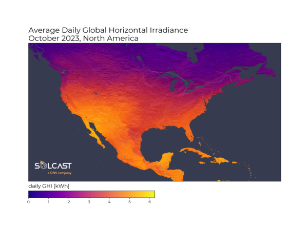
Solcast produces these figures by tracking clouds and aerosols at 1-2km resolution globally, using satellite data and proprietary AI/ML algorithms. This data is used to drive irradiance models, enabling Solcast to calculate irradiance at high resolution, with a typical bias of less than 2%, and also cloud-tracking forecasts. This data is used by more than 300 companies managing over 150 GW of solar assets globally.
The views and opinions expressed in this article are the author’s own, and do not necessarily reflect those held by pv magazine.
This content is protected by copyright and may not be reused. If you want to cooperate with us and would like to reuse some of our content, please contact: editors@pv-magazine.com.

3 comments
By submitting this form you agree to pv magazine using your data for the purposes of publishing your comment.
Your personal data will only be disclosed or otherwise transmitted to third parties for the purposes of spam filtering or if this is necessary for technical maintenance of the website. Any other transfer to third parties will not take place unless this is justified on the basis of applicable data protection regulations or if pv magazine is legally obliged to do so.
You may revoke this consent at any time with effect for the future, in which case your personal data will be deleted immediately. Otherwise, your data will be deleted if pv magazine has processed your request or the purpose of data storage is fulfilled.
Further information on data privacy can be found in our Data Protection Policy.