Record-dry April lifts irradiance across Eastern Australia

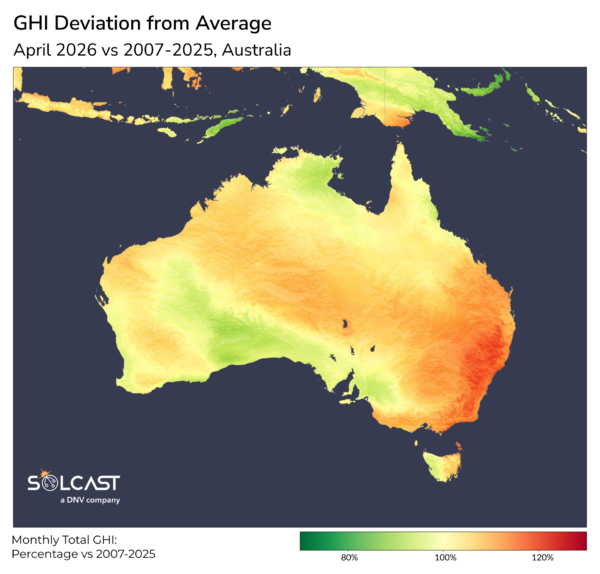
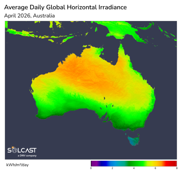
April 2026 was one of Australia’s driest Aprils in recent years, with a persistent high-pressure pattern and the return of ENSO to neutral conditions combining to suppress cloud cover and lift solar irradiance across much of the continent. According to analysis using the Solcast API, global horizontal irradiance (GHI) tracked above normal in most regions, with New South Wales and Victoria the clear beneficiaries, while cloud and rainfall linked to ex-Tropical Cyclone Maila limited gains in the north.
The dominant weather feature through April was a slow-moving high-pressure system that travelled from the west across southern Australia before stalling in the Tasman Sea. This pattern produced extended periods of clear skies, cool nights, and warm sunny days. Nationally, Bureau of Meteorology reports rainfall totals were 43% below the long-term April average, the lowest since 2018, with every state and territory recording below-average rainfall except the Northern Territory. These conditions coincided with ENSO returning to neutral after La Niña, a phase typically associated with enhanced tropical moisture and cloud across northern and central Australia. The reduction of that moisture influence coincides with a turnaround in fortune for the continent from the cloudier conditions in prior months.
Parts of New South Wales and Victoria stood out as the strongest performers. Mid-month, a cold front brought a brief period of cooler conditions to the southeast, including snow and rainfall. This was followed by a drier air mass and a return to sunnier conditions. Later in the month, a blocking high in the Tasman Sea led to very stable weather across southern Australia, with little day-to-day variation. Inland areas of the southeast experienced prolonged favourable solar conditions, with warm northerly winds and unusually clear weather contributing to a solar surplus of up to 15% above normal.
In contrast, conditions in northern Australia were shaped by the remnants of Tropical Cyclone Maila. The system formed in the Solomon Sea on 2 April and intensified to a Category 5 cyclone by 8 April, affecting more than 119,000 people across Papua New Guinea and the Solomon Islands. By 11 April it had been classified as an ex-tropical cyclone but continued across far north Queensland and the Northern Territory, bringing cloud, heavy rain, and thunderstorms westward. This rainfall contributed to the Northern Territory recording near-average rainfall for the month, in contrast to the widespread dryness elsewhere. The coastal fringe of southern Western Australia and parts South Australia also bucked the trend of the rest of the country, recording below-average irradiance, at around 5% less than normal.
Solcast produces these figures by tracking clouds and aerosols at 1-2km resolution globally, using satellite data and proprietary AI/ML algorithms. This data is used to drive irradiance models, enabling Solcast to calculate irradiance at high resolution, with typical bias of less than 2%, and also cloud-tracking forecasts. This data is used by more than 350 companies managing over 300 GW of solar assets globally.
The views and opinions expressed in this article are the author’s own, and do not necessarily reflect those held by pv magazine.
This content is protected by copyright and may not be reused. If you want to cooperate with us and would like to reuse some of our content, please contact: [email protected].
Please login to comment